
A high resolution climate dataset is produced to support regional and local scale assessments of climate change impacts and help guide sustainability studies in the Northeastern United States. Bias corrected CESM projections under a high impacts emissions scenario (Representative Concentration Pathway (RCP) 8.5) were dynamically downscaled using the Weather Research and Forecasting (WRF) model to 3km horizontal resolution. This dataset can be used in regional-scale ecosystem, hydrology, economy and other impact assessment models that need higher resolution data than those obtained from earth system models to assess regional impacts of climate change. All input, boundary, restart and output files are available to the public through this data portal. As such, it can also be used for further downscaling studies.
Understanding how climate change will impact New England's ecosystems and ecosystem services in the future requires simulating future changes in regional climatology and extreme weather events. Projections of Earth System Models are simply too course to assess changes at regional scales, nor are they scale appropriate for use in regional assessments and analysis of climate change impacts.
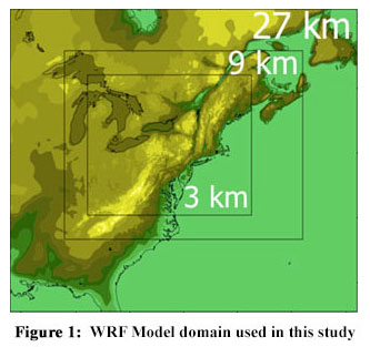
To create a high resolution climate dataset that will enable enhanced future projections and hence detailed impacts assessment studies, we dynamically downscaled Earth System Model projections under a high impact emissions scenario. We used the bias corrected CESM projections under RCP 8.5 generated at the National Center for Atmospheric Research (NCAR) for regional climate modeling studies (Monaghan et al. 2014; Bruyere et al. 2014). We dynamically downscaled these projections utilizing the Weather Research and Forecasting (WRF) model using three nested domains of 27, 9 and 3 km horizontal resolutions with the highest resolution domain focusing on the Northeastern United States (Figure 1).
WRF simulations were completed at the NCAR Yellowstone High Performance Computing System using our 12 million core hours CISL allocation (CNHA0001). Data including the WRF output, input and restart files in NetCDF format were transferred from NCAR to UNH for further archiving, post-processing, and hosting for public access to the broader Earth sciences research community. Output from the WRF model spans approximately 2 PB of data volume. A second copy of all input, output and restart files in NetCDF format exists at Purdue University High Performance Computing Cluster Tape storage.
This study was partially supported through the New Hampshire Experimental Program to Stimulate Competitive Research (NH EPSCoR) project 1101245. We acknowledge the full support of NSF program manager, Dr. Audrey Levine, in securing the computational resources needed to complete this study. We also acknowledge the computational resources CNHA0001, UNHA0002, UNHA0003 that were awarded to us at NCAR high performance computing systems, Dave Hart and all staff at NCAR CISL for their support.